

31.10.19 - Graduate students' maps of Temagami's forests now available in book form
Associate professor Alissa North is fascinated by Temagami, a northeastern Ontario municipality that encompasses some of the largest swaths of old-growth red and white pine left on the planet.
In 2018, she and her co-instructors, assistant professor Justine Holzman and sessional lecturer Emilia Hurd, led a studio in which graduate landscape architecture students visited Temagami, then pored over databases and government publications to produce a series of maps of the region's unique ecology and topography.
"I was interested in getting our students out of their urban context," North says. "This was looking at the non-urban perspective and how a landscape architect might, through their mapping skills, be able to provide some kind of service to rural communities."
Now, thanks to a grant from the Echo Foundation, those maps have been compiled into a handsome, printed book: Forests of Temagami — An Atlas of Old and New Growth.
"In Temagami you've got all sorts of different interest groups that are in opposition in terms of what's right and what's wrong," North says, "from First Nations, to politicians, to cottagers, and to the past history of intense logging in the region."
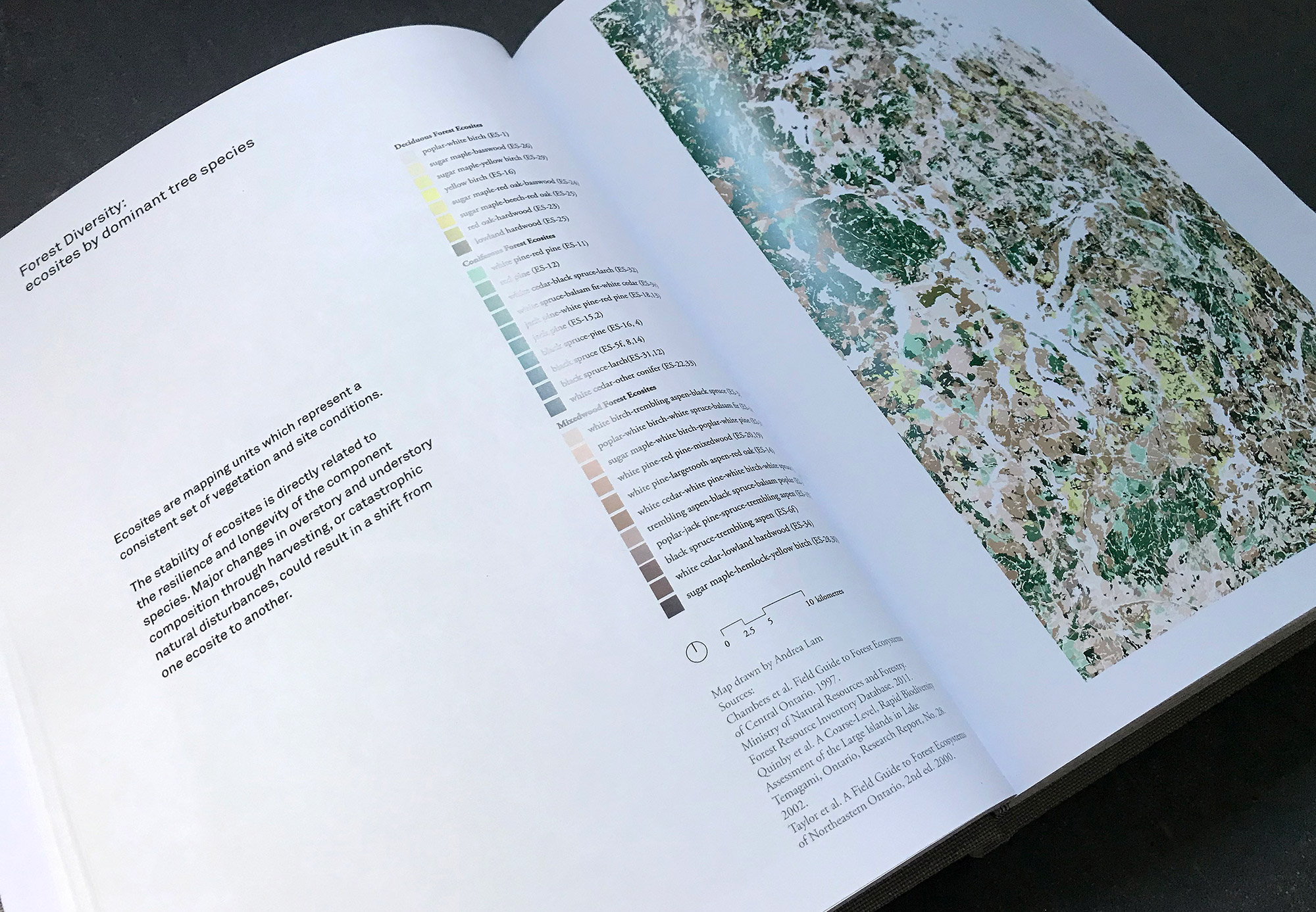
The student work on display in the atlas renders information relevant to all of those competing claims in ways that are both visually accessible and beautiful. The result is an overview of the many factors, manmade and otherwise, that continue to shape Temagami's forests. Everything is divided into five thematic sections ("Trees," "Water," "Land," "Animals," and "People"), each with an introduction from an expert.
The students' maps use disparate data sources to produce dozens of different full-colour visualizations of the condition of Temagami's forests in the past, present, and future.
Some pages treat topics of interest to recreational visitors looking for amenities like canoe routes or hiking trails. Other maps tackle the ways in which human activity has changed Temagami's landscape. One, by student Peter Jamie Reford, mashes up information about shipping routes and mining claims with the logos of logging companies that were active in the region between 1872 and 1970.
And of course there are plenty of maps that survey the state of the natural world in Temagami: its animal habitats, the types and extent of its vegetation, and even the mineral content of its bedrock. A series of five maps by student Sarvin Khosravi Fard shows not only the current shape of Temagami's old-growth forests, but also how they would spread in the future, at 50-year intervals ending in the year 2200, if they were allowed to grow free of any interference from humanity or natural disasters. Each successive map shows a larger, denser old-growth forest spreading over Temagami's landscape, until the entire region is engulfed.
Forests of Temagami — An Atlas of Old and New Growth is now available for $114, including HST. Anyone interested in buying a copy can do so by emailing Alissa North. (Students and environmental organizations can purchase the book for $45.60, a 60 per cent discount.)